Planning the 7th Annual Jeep-CJ Trail Ride

Will you make it to the Jeep-CJ.com trail ride in Colorado?

  • No thanks. I have better things to do on my time off.

    Votes: 0 0.0%

  • Total voters
    25
Planning the 7th Annual Jeep-CJ Trail Ride
Just some general comments from me:

Radio or not, you are responsible for the person behind you.
Check your mirror, make sure they are coming; if not, just pull over and stop.
The person who is in front of you will notice you're not coming and do the same.
If this works like it's supposed to, then soon all rigs are pulled over.
There is no need to turn around and go back looking, unless radio traffic or something other suggest that you turn around and go back.
Check your mirror often !

When at a major fork in the road, make sure the folks behind you see which fork you took. Wait for them at the fork.Usually not a problem above tree line, but it's a good habit to get into.

If you need to stop ie., picture, potty, or whatever, let someone know.
Advise when you're back in line or on the road again.

Potty stops to me always meant boys to the left, girls to the right.
This would be with no facilities. Facilities of course changes everything.

If at any time you want to leave the group for any reason, let someone know why you're heading back and the route you're taking. We don't want to have to look for you out in the wilderness, and then find you're back in the hot tub.
 
The plan for trail rides

This trail ride has 3 times more participant than last year. More may join and more may have to drop out but the latest tally is 18 Jeeps and 31 people to attend so far. I simply can not lead this whole group over the mountain trails.

Each day we will split into 3 groups to go over 3 separate trails. (Depending on attendance this may be cut back to 2 groups)
I have 8 trail rides planned out. Pick a trail ride for each day in advance, maybe the night before but preferably pick the whole week of trail rides when you arrive in Ouray. You can change your mind.

I will lead one group but I'll need at least 2 volunteers to lead the other groups. Please let me know if you are even slightly interested. I will gather info that will help the trail guides. You can then decide if you are willing to lead or would rather ride in back. Yes, I know, everyone is nervous about leading a group over the mountain trails.

Here's the trail rides:
Trip 1: Engineer Pass trail starting from highway 550 all the way to the top of Engineer Pass. We've never gone any further than the lookout (also known as OH Point!). We might continue on. Next we will head back to Animas Forks Ghost Town and on to Silverton.
Warning: Lower Engineer Pass Trail (also known as Mineral Creek trail) has some rock crawling.

Trip 2: Corkscrew Pass. Then we will go over Hurricane pass and California Pass then down to Animas Forks Ghost town. From there we'll go up over Cinnamon Pass to American Basin. The group will then head to Silverton and take the highway back to Ouray.

Trip 3: Minnie Gulch and Maggie Gulch. We'll drive to Silverton and head north to Minnie and later to Maggie Gulch.

Trip 4: We'll take the infamous Black Bear Pass (trust me, it's not as bad as its reputation). We'll head into Telluride and come back over Imogene Pass.
Warning: Black Bear pass may be intimidating for those with a fear of heights.

Trip 5: Beartown site. We'll take the highway to Silverton and then go over Stony Pass, cross the Rio Grande River. We will pass by Beartown site and continue to Kite Lake. Then back the way we came.

Trip 6: Poughkeepsie Gulch.
Warning: This is a more difficult trail. You need lockers to take your jeep up "The Wall". If you don't feel you are up to it you can watch the others and then take the bypass.

Trip 7: Brooklyn Trail and Clear Lake. From Red Mountain Pass we'll turn off highway 55 and climb US Basin 4x4 Road. If you thought highway 550 was high we'll be far above 550 looking down at cars that look tiny. US Basin road turns into Brooklyn trail as it descends. We'll get back on 550 for a few miles before we get on gravel and then onto Mineral road and then up the 4x4 trail to Clear Lake.

Trip 8: Velocity Basin. We'll take the highway to Silverton then head NW to the Gladstone Mining complex and we'll use Corkscrew Pass to get back "home" to Ouray.

Monday the choices are trips 1, 2 or 3
Tuesday the choices are trips 3, 4, 5
Wednesday the choices are trips 5, 6, 7
Thursday the choices are trips 7, 8, 1
Friday the choices are trips 6, 3
 
Last edited:
Being a east coast guy I don't want to step only anyone's toes. If you need me to lead a trail I'd be happy to do so however, the CO guys and 007 have been wheeling there for years. I'd be just as happy to fall in line as well.

If I'm able to wheel Sunday (which most likely I will) I'll lead a group up Poughkeepsie Gulf for whoever wants to go.
Us too. We could lead a group, but, like Posi, would much prefer to defer to one of the members from Colorado. I am also happy to bring up the rear and make sure everyone is still with us and has not broken down. Possibly one of the regulars leading and another bringing up the rear? (of course, if we break down, that's a different story! :eek: :laugh:) I know that all of us who have been wheeling out there together for several years would like to wheel together on at least a couple of trails, but also look forward to meeting all the first timers. Whatever makes things work is fine with us.
 
For the radio guys:

https://www.walcottradio.com/uniden...-modern-sleek-design-and-features-p-3068.html

https://www.walcottradio.com/cobra-75wxst-remote-cb-weather-radio-p-520.html

Would either of these be an ok choice for trail use? I don't really have a place to mount a full size CB radio. Also, what is my best option for an antenna and mount and where to mount?

Thanks,
Dave

Either is fine. I have one similar to the first one myself. We've used handheld CB's as well. No worries.
 
We have a spare CB radio with an antenna we will bring along if anyone needs one. It is set up for a 12 volt lighter port, but could be hard wired if necessary. Posi and Rad used it last year. Now they claim they couldn't always hear us, usually when they were exploring a side trial.... :poke: :laugh: We have tested it and it seems to work fine. ;)
 
Haha, could have been playing behind an obstacle blocking the signal. I may need it again. The seller's kid rifled through the jeep after I bought it and took the cb and farm jack. Not concerned with the jack someone will have in the group.
 
I have a new handheld as well that can be borrowed.


Sent from my iPhone using Tapatalk
 
I am asking other jeepers around Durango if they would lead during the trail ride. We don't yet know how many participants we'll have but I think I need to plan on 3 groups going on 3 trail rides each day.

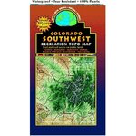
Even if you don't want to lead a group I would recommend this map:
61fkJQewIaL._SY450_.jpg
https://www.amazon.com/Southwest-Co...1&keywords=latitude+40+map+southwest+colorado
There are other maps for the trails we'll be on but I think this one is the best.

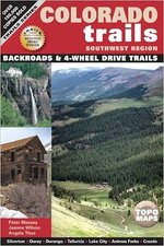
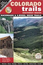
And here is the best book that covers the area we'll be riding on:
51HNAJNx%2BJL._SX331_BO1,204,203,200_.jpg
https://www.amazon.com/Colorado-Tra...id=1496371063&sr=1-3&keywords=colorado+trails

Check it out but make sure you get the book that covers the "Southwest Region". There is a whole series that covers the state of Colorado but this is the one you want.

Other members have purchased the "Guide to Colorado Backroads & 4-Wheel Drive Trails". That one is not bad but it covers the whole state. The section that covers the area we'll be riding in is relatively small and doesn't cover Minnie Gulch, Maggie Gulch or other trails we'll be going on.

I have both books. They both have GPS coordinates. The reason I prefer "Colorado Trails - Southwest Region" because the whole book pertains to the area we'll be riding in, except the end of the book does include some trails we wont see.

:driving:

When you are way up high in the mountains during this trail ride ask yourself if you could have gotten up here if Dave didn't show you the way. If you say yes you might be able to lead the 8th annual Jeep-CJ trail ride.:D
 
Last edited:
In addition to those that Dave mentioned, buying a Pro membership to AllTrails.com is good too. $30 per year.


Sent from my iPhone using Tapatalk
 
And here is the best book that covers the area we'll be riding on:
51HNAJNx%2BJL._SX331_BO1,204,203,200_.jpg
https://www.amazon.com/Colorado-Tra...id=1496371063&sr=1-3&keywords=colorado+trails

Check it out but make sure you get the book that covers the "Southwest Region". Their is a whole series that covers the state of Colorado but this is the one you want.

Other members have purchased the "Guide to Colorado Backroads & 4-Wheel Drive Trails". That one is not bad but it covers the whole state. The section that covers the area we'll be riding in is relatively small and doesn't cover Minnie Gulch, Maggie Gulch or other trails we'll be going on.

I have both books. They both have GPS coordinates. The reason I prefer "Colorado Trails - Southwest Region" because the whole book pertains to the area we'll be riding in, except the end of the book does include some trails we wont see.


So my copy arrived this morning, and it is hands-down better than the "other" one the Dave mentioned, that I already have. It does in much much better job of showing you where your trail would intersect up in the mountains with another one, and then gives you reverse directions for each trail so that you can find your way back down a different way than you came.

In addition to that, it gives a great backstory on each trail and many of the things that you'll find as you travel it.

I would consider it a must-have, even if you know your way around up there.


Sent from my iPhone using Tapatalk
 
I've been on a cruise ship for a couple weeks so just got back and read through.

My Uncle and I are used to finding our own way and spotting people on rough trails, and following maps and directions etc - so if need be I have no problem "leading" a group, though I assume someone who's been on the trail would be a better match - either way is fine for me though if I'm needed...

I love challenging and rougher trails - I think my choice would be:

M - 1
T - 4
W - 7
T - 8
F - 6

Correct that if you see better "fits" for my style of trails. I have not issues with scenic trails too, but from what I see this will take me over a lot of the passes and trails I wanted to take... Black bear is big one for me, have wanted to do this one since year one... Want to conquer the wall, love rock crawling trails etc...

Something probably Sunday, as I plan to arrive early Saturday and work out the tuning and kinks in the Jeep, so if someone (Posi said maybe) poughkeepsie Gulch Maybe Sunday I'll take that and maybe switch others around to get another trail in and order makes no difference to me if it's easier to throw me into a different group. Uncle and I will be in same group though as we know each other's rigs and habits if issues, and we share tools and rig appliances (on board air, tools, etc)

Going to buy the map and the book too just to have available.

Let me know when we need to have a solid plan by etc and / or if you're making groups be week long groups with set trails for that group each day etc - We're pretty flexible...

We're also easy early risers and long as we didn't tie one on too much the night before, even then we rally pretty good...

:chug:
 
I'll arrive in Colorado Springs morning of the 9th.
Spend a couple days working on my CJ (that I haven't laid my hands on yet).
Plan to do a Colorado Springs trail ride/shake down run on Friday the 11th, feel free to join the fun!
Driving the CJ to Ouray Saturday morning with our regular group and anyone else that wants to join in.
 
A few of you have volunteered to help lead trail rides. I appreciate it but I think it would be best if the leaders are from the area and are familiar with these trails. Anyone that wants to lead will still have an opportunity to do so but I have been asking around here for trail leaders. I think I might have found some people that would like to help lead.

I will bring 3 notepads for participants to sign up for trail rides. I hope people can sing up early such as Sunday or at least the day before. If people want to change their mind, that’s fine. Every day we’ll have a trail ride that is mild for those that have restored jeeps they don’t want to bang up. There will also be more challenging trails. I hope to have a mix each day.

Each and every year I’ve had this trail ride I always wanted to get an early start to avoid the afternoon rains. But every trail ride has never left town much earlier than 9:00 am. That is my plan for this coming trail ride: Breakfast at 8:00 and leaving town by 9 am. If a group thinks they can beat that schedule, great. Filling up with gas the night before always helps us leave on time.

Meals:
Breakfast will be at restaurants in Ouray. If your motel has breakfast that can save money (and time).

Lunch will be on the trails. Buy or make sandwiches the night before. A small cooler is nice. If you don’t have a small cooler some bring coolers that are big enough to share.

Dinner will be at restaurants in Ouray. We’ve always tried to pick one restaurant for all of us but I don’t know if that will work for such a big group. More than likely we’ll split up and have dinner at 2 or 3 places.
Later on we may find fire pit we can sit around and talk about the day or plan the next day.

One more trail I am thinking of adding to this year’s lineup is Ophir Pass. I’m thinking of going from Ouray over Imogene Pass into Telluride and then coming back over Ophir Pass. We’ll also be going over Imogene pass on our way back from Blackbear Pass but then we’ll be going the other direction. Plenty of choices. I’m really looking forward to this.

Maybe you already have some of this information. I'm reposting for anyone that missed it.
 
Here's the trail rides:
Trip 1: Engineer Pass
Trip 2: Corkscrew Pass.
Trip 3: Minnie Gulch and Maggie Gulch.
Trip 4: Black Bear Pass
Trip 5: Beartown
Trip 6: Poughkeepsie Gulch.
Trip 7: Brooklyn Trail and Clear Lake.
Trip 8: Velocity Basin.

Dave, I understand "most" of the trails are green however, it may simplify things if the trails are rated Green, Blue, or Black along with the guide below. It should be useful in picking trails for the first timers. This is only a recommendation doesn't mean if your running stock open/open you can't do poughkeepsie.


Green-stock; open, open; 32" tire size or less
Blue-33" tire size minimum, one locker strongly recommended
Black-35" tire size minimum, two lockers strongly recommended
 
Last edited:
Dave, I understand "most" of the trails are green however, it may simplify things if the trails are rated Green, Blue, or Black along with the guide below. It should be useful in picking trails for the first timers. This is only a recommendation doesn't mean if your running stock open/open you can't do poughkeepsie.


Green-stock; open, open; 32" tire size or less
Blue-33" tire size minimum, one locker strongly recommended
Black-35" tire size minimum, two lockers strongly recommended

Going down BlackBear does not take a highly skilled driver but that trail scares people because of the ledges and switchbacks. On the 3 trails that are not mild I gave a warning for the reason someone might be leery of taking that trail. As you said, most of these trails are “green” rated. You can go pretty far with 32” tires even with open diffs. Most of our CJ’s came with 28 inch tires (215/75R15). I like to say most of these trails can be done in a stock jeep. Even Lower Engineer Pass trail can be done in a stock CJ but would you want to take a nicely restored ’62 CJ5 over those rocks? Ben was not comfortable taking his pickup down that trail. What do you think of using our own rating scale?

Something like this:
Easy: Stock. open differentials. 28 inch tires.
Medium: 33 inch tires
Difficult: At least one locker.

I had a hard time finishing the above rating because I really don’t know if rating these trails by the equipment (Lockers, tire size, etc) is the right approach. A CJ with 31 inch tires and a Limited slip in the rear could do all these trails with the right driver. But the same jeep could end up on its side if a poor line is attempted. I agree we need a way to describe these trails to people that have never been here. My original idea was to verbally describe each trail instead of trying to fit them into a scale system.
Thoughts? Feedback?
 
The rating scale looks fine to me.

My first trip down Black Bear was 1972. 3 vehicles total.
The difficult to do was the brand new 1972 IH 1210 4x4 pickup.
The factory Holley 4bbl on the 392 kept flooding out and stalling.
So power brakes and steering were almost useless....and the switchbacks were very interesting as those trucks back then couldn't turn around on a football field.

We camped right in Telluride at the city park/campground.

I've always told folks that Black Bear is not hard, but it does have the pucker and wow factor you won't find anywhere else.
It's also the only trail that first gear/low range/foot on the brake can still seem to fast at times. (compound low 4 speeds excluded)

Anyways, looking forward to the trip and the return to Colorado.
 
I have no opinion on a color coding system really. I'm fine with one or without. The fact is that with the exception of just a few small stretches of trail, everything is fine with a stock Jeep on 28's. So in my opinion, Mineral Creek / Lower Engineer and some spots on Poughkeepsie are the medium / blue and everything else is easier. If I had a restored 62 CJ5 I'd be leery of those stretches and nothing else except that Rio Grande river crossing.

If you've heard of Black Bear, it should be on your to-do list because it's there and so are you. Pay attention, use low gear to manage speed and pay more attention and you'll be fine.

I've done much of this on 31's with open diffs (not Poughkeepsie wall) and 31's with a posi-trac and never noticed a difference. Posi did much of this in a TJ with negative lift and bald street tires. You need to have your brakes and drivetrain in good working order out there and everything else is icing on the cake.

Sometimes the biggest challenge is enjoying the beauty and staying on the trail at the same time. It's just flat out beautiful there.

That's my 2cts.
 
The color code was just a thought because we use them in the northeast on every trail. I can see where it wouldn't be needed on the trails we will be running, and your description of the trails is informative.

As I previously mention most all the trails we run is green/easy. Fact is, you could do 90% of the trails we run in 2 wheel drive.
 

Jeep-CJ Donation Drive

Help support Jeep-CJ.com by making a donation.

Help support Jeep-CJ.com by making a donation.
Goal
$200.00
Earned
$0.00
This donation drive ends in
Back
Top Bottom