9th Annual Jeep-CJ Trail REPORT

9th Annual Jeep-CJ Trail REPORT
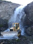
Wednesday we ran Silver Mt trail and stopped at the Silver Mt Mine and Lost Day Mine.
We continued on Corkscrew, Hurricane, Pass, Placer Gulch, Picayune Gulch, and Gladstone area. We stopped at Midnight Mine, Carbonate King Mine, Mogul Mine, Bride of Bonita Mine, Adams Mine, Gold King Mine, Silver Ledge Mine, and Lead Carbonate Mill. Its possible we visited a couple of these Mines on Thursday not Wednesday.

8dbc85f3340202888a1fa35e1d431d0d.jpg

300474ca0e530b1e9dbd852382baccc9.jpg

a3c89399d3745a15465f53ad1f62987a.jpg

33d5198a431d893501ffc205c50bceb7.jpg

df301e224a24159351b430e23590e1b9.jpg

8a4c0f17c10ce4236b6028ca54d59655.jpg

64723fb46fe16e1364530812eabe56a5.jpg

4fced8d49e09fa1a6308eb587e3de748.jpg


c308dc4aa73a2760b0a16ac323c1f1d1.jpg

343d661bcc9d41e059dbce97795540ff.jpg

2b6a9336eb270f11189b3f89cf4aaf00.jpg

1b414fc63917a41aa17f47c5335094ec.jpg

4ebb9dc184a3ae985c577057451f779d.jpg


0d4cb473f03721e3febaa67aeecc3665.jpg

f1f265d15f7bc46350789c291e926511.jpg

827a4f9960ed0afe8c161bb155008168.jpg

6813ccc92d7aa96c20761f55942d8437.jpg

79a408977dddd5731c3d3e23b01fedf2.jpg

11ed75ef92afaf8bdad1d76348c3fecb.jpg


d6ca5954db824e7d227cd46d3d86b7b4.jpg


Sent from my iPhone using Tapatalk
 
d87f367cb47586c65e678aa1f3dae687.jpg

7c4a92c1164850a8ec0dee466ccad576.jpg

031f276f8c165c2f857a90f193272a50.jpg

fdf5009cd0d5d88b324f98cdcda09d27.jpg

8a8186aa873317e84de7b61310b28906.jpg


2c79d239ed5fff563e05da7bf98228f0.jpg

d433ddfd8770b26a8b81bbdec17182bf.jpg

4900622ea4f606bd912f7d30c732f4f7.jpg

7211b2c7d0d93624e0e69b09a0c2c432.jpg

f4718e87c3d4309136fc10435d7bc34a.jpg

96020c79a2574b351e2e84b27c8083c8.jpg

fd7deb7acf1828e68c088b78498539b2.jpg


438ccf470faa865bbd9500c701276c1c.jpg

2c2e2d0945332f349439f7b7e0f7bb24.jpg


Sent from my iPhone using Tapatalk
 
That was a cool mine camp to explore. Sent my little cousin inside for some photos too.
 
fd7deb7acf1828e68c088b78498539b2.jpg


This was when there was a thought to be all wheel but really only 2 wheel drive van blocking the trail, Posi went to assist, and the guy that was riding my bumper down the trail (not in our group) and I exchanged a few words about older vehicle brakes, and low gearing... :cool:

Ended up the poor guy was a local just trying to make it to Silverton in time to get his lady a funnel cake before they closed. I told them I'd rush them through ASAP to get that cake! We let them pass as soon as we were clear of the avalanche area and the trail widened back up.

We got to the end of the trail and seen the van all beat up parked there, and another group showed us a video of part of the avalanche wall starting to slide down on him, wasn't serious but from the video perspective it could have been and he was prepared to push his partner through the trail to get out of the path. Was funny at that point, but could tell he was amped up from the situation earlier still. A large piece of "ice-snow" had fallen on the hard top right over his wife I believe. Not terrible damage, but was thankful he was not in a soft top.

:chug: - photos to come still...
 
^^^^

832ba59e4eb151e23e069e848bb7f406.jpg


Sent from my iPhone using Tapatalk
 
Thursday August 8th

We split up into two groups. I led one group and Posi led the other.
I led my group up Kendall Mountain. This trail goes up the mountain overlooking Silverton. Along the side of the trail is this old rail car.

48511678311_052e17eaba_b.jpg

on the way up the mountain Loyd broke a rear axle shaft.

48511677896_274a1fa89d_b.jpg

JR and others from California helped Lloyd as he limped back to town.
Before reaching the top we encountered this snow field preventing us from going the last little bit to the end of the trail.

48511858507_8bc1f12fa1_b.jpg

With a smaller group we decided to meet up with Posi's group.
I was not able to contact Posi until we drove up high over the Gladstone mining complex.

48511857907_b50588fb3a_b.jpg

After reaching Posi via radio we joined his group.
Posi led us up Prospect Gulch to the Lark Mine.

48511676516_67cca0ec89_b.jpg

48511856842_0d9f20d88d_b.jpg

48511856342_dd171cd393_b.jpg

As we were leaving Lark Mine Posi got a flat and had to change out his tire.

48511855982_ffb372b53e_b.jpg

48511674576_140abc583c_b.jpg

My jeep was making a bad noise only when I would activate the front axle. The rest of the group continued to the top.

48511674131_6898a6bba9_b.jpg

I broke a couple of teeth off the ring gear in my front axle but I was able to drive in two wheel drive.
Despite our problems we were all able to come back to Ouray.

To be continued ...
 
bae7c8ae5bb133234b348edbe60c7329.jpg

9a4c005d041d07fdd3005bbe9e51e698.jpg

946bec26a4210e5c635eb3901c9ec330.jpg


4cf68c2114eafa09e3844c54469dc90e.jpg

22cb025b89af26b1879d746256506e84.jpg

0c039998b6cefbf6e8022bcd644d8d91.jpg

dd085e7e0a4111815a93f518d2e5aede.jpg

916dd4f251a3257a83608dcf05650a8c.jpg

58f6e3c3f42fbc162aa648e0faae937b.jpg

c3b16ce4e6f474a71f961b6371267760.jpg

4d2c424849aa64093bab2c866d42282e.jpg

15a9ef46268414d68733bcc7f0c2a03b.jpg

adcfd1218d51488022c5b89427bd3ddc.jpg

a5a36aced0aa06c8c658057767d61431.jpg


3ae375d6b83f28b6afa85aa28394c535.jpg

e59978cad33fe765fa0adda31a45e38b.jpg

e343cf4b414a4705512b25e63c62d5e2.jpg

71e520f2af2a0d61b314f4e839a4e026.jpg

13a98b0841d84f8fd03aec43a1de6d21.jpg

5c956325e05bd02baa1ce971399d9f15.jpg

The below pic was taken from 150-200 yrds from the peak of Red Mt 3.

3c3eebf6bee4bf23080092aa5ac9e51a.jpg


Sent from my iPhone using Tapatalk
 
Friday August 9th

With a broken ring gear I decided not to take my jeep in two wheel drive.

Instead I hopped in PistolDave's CJ7. Posi lead us on a trail that went into the Ouray amphitheatre . Most amphitheatres are places for open air entertainment such as music festivals but the amphitheatre near Ouray is call an amphitheatre only because the mountains curve around like an ancient Greek amphitheatre. There is a campground in the amphitheatre but we went on a trail that did not go through the campground.

We went up to the Portland Mine. I haven't been there in years.

48511875312_15af926f80_b.jpg

There was still a lot of snow that was covered in avalanche debris.

48511695816_ef157a23fd_b.jpg

Here's a closeup

48511876542_727e8e2e64_b.jpg

Next Posi led us back onto highway 550 south to the Red Mountain Mining district.

48511693661_e902a9e11d_b.jpg

48511692761_ac4e76155b_b.jpg

48511874472_29ef468ea2_b.jpg

48511699996_fab037f15f_b.jpg

48511699576_fa1b299506_b.jpg

This is the Yankee Girl Mine, a deep vertical mine.

48511699121_be7a5c659c_b.jpg

48511880077_05d84504d6_b.jpg

48511879682_4799d307f4_b.jpg

Next we went to Black Bear Pass. We knew this was closed but we were curious how far we could get.

We encountered some sheep on the trail.

We got past the spot that snow blocked me 10 days ago. I saw a few places that people when off the trail onto the delicate tundra grass.
Then we got to a fork. The easy way is to the left and the hard way is to the right. This year the hard way looked impossible but Bobbie and Posi wanted to give it a try.

48511879317_297be80822_b.jpg

The rest of us took the easy way. Here's the same view but from the top of the hard section.

48511879012_a27fb1fb75_b.jpg

48511697171_1ee3af1554_b.jpg

At the summit we found another snow field.

48511878232_045e82a36d_b.jpg

48511696591_11bb093409_b.jpg

There is a legal fork that bypassed the snowfield. It was easy to come down the snowfield but no one was able to go up it.

48511696281_4e404617d9_b.jpg

We headed back to Ouray. This ended the 9th Annual Jeep-CJ Colorado Trail ride.
 
There's been a lot of accidents in the mountains this year. A woman was swept away when her jeep failed to cross Pole Creek. A jeep rolled over it's driver on the Kendall Mountain trail and just yesterday a jeep rolled down an embankment on Imogene pass.

The two occupants are hospitalized.
 

Attachments

  • Imogene Pass rescue.jpg
    Imogene Pass rescue.jpg
    100.2 KB · Views: 75
  • Imogene Pass crash1.jpg
    Imogene Pass crash1.jpg
    101.5 KB · Views: 66
  • Imogene Pass crash.jpg
    Imogene Pass crash.jpg
    100 KB · Views: 73
There's been a lot of accidents in the mountains this year. A woman was swept away when her jeep failed to cross Pole Creek. A jeep rolled over it's driver on the Kendall Mountain trail and just yesterday a jeep rolled down an embankment on Imogene pass.

The two occupants are hospitalized.

Dang so glad we didnt have problems like that.
 
Thats a steep embankment. If you hear more about this and what went wrong, I would be interested. Always good to learn from others miss steps and mistakes and what not to do. Thanks
 
Thats a steep embankment. If you hear more about this and what went wrong, I would be interested. Always good to learn from others miss steps and mistakes and what not to do. Thanks

The photos and this quote are from the San Miguel Sheriff's Office.

A multi-agency technical rope rescue with threats of rockfall was required to rescue a couple who rolled their Jeep approximately 450 feet down steep terrain off Tomboy Road near Royer Gulch on their way to Telluride. It’s believed the incident occurred some time before the wife was able to place a call to 911. More than 35 people including Telluride Fire Protection District EMS and Fire personnel, San Miguel Sheriff’s Deputies, San Miguel County Search and Rescue and willing bystanders participated in the nearly five hour mission. The Montrose couple, both 72yrs-old, sustained multiple, critical injuries, and were transported by Telluride EMS to the Telluride Medical Center and then flown by medical helicopters to St. Mary’s Hospital in Grand Junction
This road is between Telluride and Tom Boy townsite.
 

Attachments

  • Imogene Pass crash Interior.jpg
    Imogene Pass crash Interior.jpg
    100.1 KB · Views: 33
450 feet ! Amazing they survived and the jeep looks that good.
 
Thats a steep embankment. If you hear more about this and what went wrong, I would be interested. Always good to learn from others miss steps and mistakes and what not to do. Thanks

Pure speculation, but there are so many areas there that are too small for 2 way traffic, and depending on the size of oncoming rigs etc, sometimes people still do pull to the side to allow another to pass vs the dangerous potentially backing up.

I could easily imagine pulling too far to the edge and either soft ground gives way to slide the jeep, a tire blows initiating inertia over the edge, or a bump from passing rig unexpectedly nudged them over.

I expect the full story would be something along one of those lines, if not just pure driver error...

Hope they make a full recovery!
 
Black Bear pass is now open although it's too late for us.

25773d1566255562-9th-annual-jeep-cj-trail-report-black-bear-pass-open.jpg
 

Attachments

  • Black Bear Pass is open.jpg
    Black Bear Pass is open.jpg
    64.6 KB · Views: 91
IMG_3254.JPGIMG_3250.JPGIMG_3251.JPGIMG_3240.JPG


Sent from my iPhone using Tapatalk
 
Thanks again all for the pics they were great.
One question...........did you see any "critters" Deer, Elk, Pronghorn, bears? Looks to be some great wildlife habitat.
 
Thanks again all for the pics they were great.
One question...........did you see any "critters" Deer, Elk, Pronghorn, bears? Looks to be some great wildlife habitat.
Plenty of Mule Deer, one year I counted over 15 heading back on 550 to Ouray from Silverton. Their smart, they look both ways before crossing and wait for you to pass.
Plenty of black bears, but I've only heard them at night in the dumpster and garbage cans looking for food. Moose, hawks, eagles, marmots, squirrels, and elk.
I know there is mt goats, big horn sheep, and cougars, but I haven't been lucky enough to spot one.
 
I have a couple blurry photos of a deer we snuck up on (with fender well headers and a V8... lol).

More than likely she was just waiting for me to pass too. Was just on the side of the trail a jeep width away from me then when I stopped to grab the phone for photo, she took off into the trees a bit.

I took a few photos of her, then started to move again and she dissapeared. Next thing you know she (assume same one) jumped across the trail to the other side about 20 yards ahead of me.

probably thinking "I was going to let you pass but you're on your phone dumb CA driver..." or something to that effect... lol

:chug:
 

Jeep-CJ Donation Drive

Help support Jeep-CJ.com by making a donation.

Help support Jeep-CJ.com by making a donation.
Goal
$200.00
Earned
$0.00
This donation drive ends in
Back
Top Bottom
AdBlock Detected

I get it, I'm a Jeep owner and ad-block detectors kinda stink but ads are needed on this site. This is a CJ site, all the ads are set for autos (some times others get through.) I cannot make them just for Jeeps but I try.

Please allow ads as they help keep this site running by offsetting the costs of software and server fees.
Clicking on No Thanks will temporarily disable this message.
I've Disabled AdBlock    No Thanks